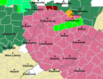
Much of West Virginia was under a severe thunderstorm watch Wednesday afternoon with potentially damaging wind gusts and penny-sized hail, according to the National Weather Service.
The storms bring the possibility of flooding – and not just near rivers.
“Pretty much anywhere that has seen heavy rainfall the past few days is at risk of some flash flooding,” said Meteorologist Joe Curtis with the National Weather Service in Charleston. “In addition to that, we could also see flash flooding in urban areas. We can see some really heavy rainfall where the water doesn’t drain well, and that can cause some flash flooding as well.”
The National Weather Service warns drivers not to proceed if you can’t see the road. Storms are expected to end by early Thursday, followed by dry, summer-like weather through the weekend.
Add WVPB as a preferred source on Google to see more from our team