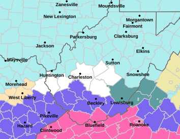
A winter weather advisory is in effect until 10 p.m. Saturday, with likely snow accumulations of 2 to 4 inches for portions of southern and southeastern West Virginia.
“We’re mainly expecting that across the southern coal fields of the state. So this would include counties like Mingo County, Logan County, Boone County, McDowell County,” Meteorologist Simone Lewis with the Charleston office of the National Weather Service, said.
For the rest of the state, a cold weather advisory means windchills as low as negative 20.
“If you have to go outside, it is advised that you wear multiple layers of clothing, including, of course, hat, gloves, all that. And if you have to travel, pack extra clothes with you, including blankets. You have a full tank of gas. And it’s also not a bad idea to just let somebody know, ‘Hey, I’m traveling this way. This is my expected arrival time,’” Lewis said.
Dr. Steven Eshenaur, health officer for the Kanawha-Charleston Health Department, said exposure to these extreme temperatures is dangerous.
“Any skin that is exposed for any significant period of time is at risk of frostbite. Of course, frostbite in your toes and fingers is also a high risk, even if you’re wearing shoes,” Eshenaur said.
For those who are unhoused or whose homes lose power, he added, it’s particularly important to find out where warming centers in your area are located.
“When it’s that cold, it is so important to try to get a plan and get to a shelter, get with somebody that you can stay with, to try to stay out of these temperatures,” Eshenaur said.
Temperatures in West Virginia are expected to warm up to around 32 degrees by Tuesday, or even warmer.