


Fourth Annual Women Warriors Summit To Feature High Profile Speakers
The fourth annual Women Warriors Summit will take place at the Marshall Health Network Arena in Huntington on Friday, Oct. 23, 2026.
Continue Reading Take Me to More NewsAlert (09/29/2026): Our Parkersburg TV transmitter is still undergoing maintenance and remains temporarily inoperative. We apologize for the inconvenience.
All our programming is available via our TV livestreams on our website and WVPB Passport. Thank you for your patience!




To Educate, Inform, and Inspire by Telling West Virginia's Story

Mountain Readers 2026 has concluded! Please fill out our volunteer post-survey.

Nominate an exceptional West Virginia K-12 teacher today!

On Demand

On Demand

Stream original productions from WVPB

Watch locally produced documentaries & more.

On Demand

On Demand






West Virginia Morning

Inside Appalachia
West Virginia Week
Mountain Stage
Us & Them

The Legislature Today
The Legislature This Week

Send us your comments and questions.

Stream our board meetings.

Check out the latest WVPB news.

Sign up for our newsletter and get weekly updates.

Meet the WVPB staff.

WV Educational Broadcasting Commission, the WVPB Foundation, and the Friends of WVPB.

Come work with us!

Read our annual report and learn how we educate, inform and inspire with your support.

Sponsor impactful and engaging media and entertainment.

Use your IRA to make a gift to WVPB.

Become a member with your gift of $1,000 or more.

Make WVPB part of your legacy.

Manage your membership account.

Learn how you can Protect and Sustain West Virginia Public Broadcasting.
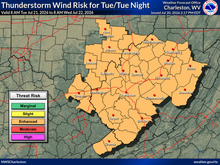
Southeast Ohio, northeast Kentucky, and almost all of West Virginia are under a level three enhanced risk for severe weather.
The National Weather Service says thunderstorms Tuesday afternoon and evening “could produce damaging winds and hail, particularly with a line that moves southeast ahead of an advancing cold front.”
The system is likely to include high intensity rainfall up to two and a half inches, thunderstorms and damaging wind gusts of 60 miles per hour or more.
“It looks like the main threat we’re going to be focusing on is going to be damaging wind. Can’t rule out an isolated tornado, particularly along the Ohio River, and potential also for some large hail,” meteorologist Nick Webb said.
“The southern part of the state probably stands the greatest chance of seeing at least isolated instances of flash flooding,” he added. “It’s going to be of high intensity, high rainfall rate, short duration, generally looking at about an inch of rain, and of course, folks that get hit with more stronger cells could stand to see two to two and a half inches.”
The public is encouraged to secure loose outside items, avoid rain-covered roads and stay tuned to local weather watches and warnings.
Add WVPB as a preferred source on Google to see more from our team

The West Virginia Mine Wars Museum is getting a sizable donation from retired union leader Cecil Roberts.
Continue Reading Take Me to More NewsKentucky regulators have given Kentucky Power the go-ahead to build a new cooling tower at its Mitchell coal plant in West Virginia.
Continue Reading Take Me to More NewsThe nonprofit newsroom ProPublica has been reporting on the use of public money to fund private education. Earlier this month, ProPublica published a series of stories about how they, along with Mountain State Spotlight, opened a school in West Virginia. Reporter Jennifer Smith Richards spoke with Chris Schulz about the experience and what it says about modern education.
Continue Reading Take Me to More NewsAn old high school will be transformed for use as a learn-and-earn program designed to create a healthcare workforce ready for jobs in rural counties.
Continue Reading Take Me to More News