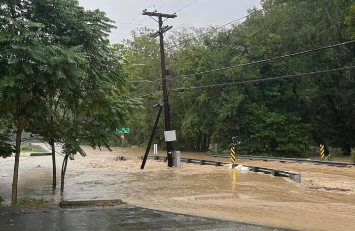
Flood events are becoming more frequent and severe in West Virginia, causing millions of dollars in damage to property, disrupting communities and displacing lives.
Curtis Tate spoke with Nicolas Zegre, an associate professor of forest hydrology at West Virginia University (WVU), about what’s behind this trend.
This interview has been edited for length and clarity.
Tate: What makes West Virginia and Appalachia so vulnerable to severe, frequent floods?
Zegre: When we think about floods, in particular West Virginia, we have to think about them two ways. One is what we call a riverine based flood. So the larger rivers that flood when they spill over the stream, the riverbanks onto the floodplain, which of course are normally dry areas. And so when we look at flooding in West Virginia and we see that riverine flooding, there are hot spots in the Eastern Panhandle, where we see a lot of that riverine flooding, and that’s associated with the ridge and valley, the large rivers like the Potomac, that the ridge and valley topography kind of creates these really wide river valleys that provide a floodplain and we certainly have that in other parts of the state. But when we think about hot spots in the state, the Eastern Panhandle, the riverine flooding is a big problem.
But the other type of flooding we’re concerned about in West Virginia is flash flooding. And flash flooding can happen anywhere. It can happen, certainly in our small streams and our heavily dissected headwater valleys where 85 percent of our streams in West Virginia are small streams. And, of course, we know we have people living up and down just about every hollow in West Virginia.
And so we actually have two hot spots, we have a hot spot in the West Fork watershed in that Clarksburg-Bridgeport Harrison County area. And then we also see a flash flooding hot spot kind of central to Kanawha and what we refer to as kind of the southern coalfield counties. Now, that said, flash flooding and riverine flooding does happen everywhere throughout the state. But if we’re thinking about a higher propensity for flash flooding, or for riverine flooding, we do see these emerging trends on where there is a greater probability of them happening.
Tate: So for example, in the 2016 flood disaster in southern West Virginia, was it more the second type?
Zegre: It was actually both. When they started collecting stories of what the 2016 flood looked like, and from the community and the first responder perspectives, and then when we started looking at what the floods look like from a hydrology perspective, what became clear was it was a different type of flood in different parts of the Greenbrier watershed. So around Richwood and Rainelle, for example, that was more a flash flood, a wall of water moving very, very quickly downslope.
Whereas, when you were in the White Sulphur Springs and kind of Lewisburg area, it was more of a riverine flood, where the water, the river level rose and kind of spilled over and filled the wider valley. And what’s interesting, Curtis, is when you start thinking about where the damage was, and vulnerability, and also recovery, we saw very different damage and very different approaches to response and recovery in Rainelle versus White Sulphur Springs. And we can tie that back to the different types of floods. But I should say that, in the case of the 2016 flood, there were a lot of flash floods that routed downstream that also contributed to the larger riverine flood. And so we can have multiple types of floods occurring in the same event, which is going to be related to the topography and the stream channel and what all that looks like.
Tate: What’s driving the heavier rainfall?
Zegre: So heavy rainfalls are the result of a warmer atmosphere. We think of the atmosphere as like a balloon, and if you blow up the balloon in your house in January, and it’s warm inside your house, the balloon is expanded. And if you walk outside, on that cold winter day, that balloon is going to contract, walk back inside to that warm house and then the balloon is going to expand. So that’s what’s happening with warming temperatures in the atmosphere.
With a warmer temperature, the atmosphere expands, which means it can store more water. But with warmer temperatures, there’s more evaporation of water from our soils, in our trees and our rivers and our lakes. And so, more water has been put into the atmosphere and more of that water can be stored in the atmosphere. And once the atmosphere reaches saturation, we have these very heavy intense rainfalls, and so heavy rainfall and air temperature is very clearly related. In fact, for a single one degree temperature increase, a one degree Fahrenheit increase in air temperature, the atmosphere can hold 4 percent more water. And so, as the atmosphere warms, that holds more water, and it creates more rainfall.
Tate: How much does land use, whether commercial, residential or industrial, contribute to the problem?
Zegre: Whether it is, you know, what we would call an old growth forest, or a Walmart parking lot, if you drop eight to 10 inches of rain in a couple of hours, like what was experienced in eastern Kentucky, two summers ago, there’s going to be flooding in it. Our systems just aren’t designed to handle that much water. But land use activities very much affect how quickly water runs off. And so impervious surfaces associated with industrialization, associated with urbanization, and associated with the result of surface mining, all of this routes water more quickly, more water is routed more quickly off that landscape.
And so when we think about how we mitigate these effects of extreme rainfall and flooding, putting our landscape back into forests is a really important part of this conversation. But land use is a really important driver of flooding. But I should also say that, it’s really hard to detect the effects of a single neighborhood or single mine, or a single clear-cut parcel and the effect that, that has on flooding. And so we often think about this, we know how water cycles through the atmosphere and through the earth. And so what happens when you remove forests and remove soils, that water can’t be stored and that water is not removed from runoff, so all of that goes downstream.