Rising Rivers, Possible Rockslides From Snow Melt And Rain

Rivers across the state are expected to rise over Friday night and into Saturday, due to snow melt and heavy rainfall. 

West Virginia rivers are rising due to snow melt and heavy rainfall. The Tygart River near Philippi and Belington is expected to enter flood stage with Friday’s afternoon rain.

Rivers across the state are expected to rise over Friday night and into Saturday. 

Jeremy Micheal, a meteorologist with the National Weather Service, said snow melt has saturated the soil, limiting its ability to absorb rain water. 

“When you add on the rain, and then the accelerated additional snow melt that we had overnight, and then this morning, it definitely can cause issues,” Micheal said. 

The West Virginia Emergency Management Division has warned against rockslides. 

“With the recent rainfall, rockslides can happen suddenly, so we encourage drivers to remain alert and cautious,” said a West Virginia Emergency Management Division official in the press release. 

The central and southern half of the state are under a flood watch. Micheal said it’s important to pay attention to changing conditions, and to never try and cross moving water. 

Micheal said rain is expected to stop over the weekend as warmer weather moves in. 

The Ohio River is expected to crest at about 42 feet on Sunday evening.

Rivers and Lakes Compromised After Dry Summer

The drought-like conditions blanketing the state are starting to cause problems for lakes and streams, especially in the northern region. 

The drought-like conditions blanketing the state are starting to cause problems for lakes and streams, especially in the northern region. 

Stream flow across the central Appalachian region is ranging from low to very low, following a hot summer with little rainfall. One of those waterways is the Tygart Valley River, which supplies water to Tygart Lake in Grafton.

The valley has received no measurable precipitation since July 5. This month water levels have dropped approximately two feet per week at the lake’s gauge.

The lake has now reached record low levels and has required the marina to close early.  The U.S. The Army Corps of Engineers says the drought will affect water quality, navigation, recreation and public health due to the increased risk of harmful algae blooms and other water-related hazards. 

W.Va. Facing Drought Conditions

July has been an abnormally dry month, leading to drought conditions in many areas of the state. Around 60 percent of the state is experiencing moderate to severe drought conditions. Another 30 percent are experiencing dry conditions. 

July has been an abnormally dry month, leading to drought conditions in many areas of the state. Around 60 percent of the state is experiencing moderate to severe drought conditions. Another 30 percent is experiencing dry conditions. 

Stream flow in West Virginia, and the Appalachian region at large, is low. Some streams are at record low levels. Plants across the state are starting to dry out and turn to fall-like colors.  

A La Nina year, which usually means drier conditions for the eastern seaboard, paired with record heat waves, has translated into a dry, hot summer for the majority of the Mountain State. 

Officials from the National Weather Service say that even though rain is likely later in the week, it won’t be enough to buck ongoing drought conditions. That will take a heavy, widespread and lasting rain event that results in several inches of rainfall.

April Showers Could Bring Floods, Help Ebb Fires

The National Weather Service (NWS) has issued a flood watch for the northern two-thirds of the state. The warning extends until Tuesday night with more rainfall and severe weather on the way later in the week. The weather service advises residents to be ready to take action to stay safe. The rainfall could be beneficial, however, for the ongoing fires in the Eastern Panhandle. 

The National Weather Service (NWS) has issued a flood watch for the northern two-thirds of the state. The warning extends until Tuesday night with more rainfall and severe weather on the way later in the week. The weather service advises residents to be ready to take action to stay safe. 

John Peck, a meteorologist at the National Weather Service, said that residents along waterways anywhere within the flood area need to practice heightened caution and awareness. 

“Anybody that’s in those lower lying areas or has interest along creeks, streams and rivers,” Peck said. “Be advised to move any personal property away from those locations.”

The rainfall could be beneficial for the ongoing fires in the Eastern Panhandle

“The rain will help moisten up the fields,” Peck said. “Which will reduce the potential for wildfire spread. And it should help any wildland firefighters take care of any issues that are lingering out there.”

The wet front is expected to waver north to south throughout the week, rendering it hard to know where some of the heaviest rainfall will likely occur. 

“Just important to know that there will be some potential for some heavy rain out there, perhaps some persistent heavy rain for some locations,” Peck said. 

Peck said that as the spring progresses and the larger mountain vegetation, like trees, begin leafing the land will be able to absorb more rain. But now, with only smaller vegetation out of winter dormancy, a lot of the rainfall is still running off the mountain. 

“This early in the season where you don’t have all the vegetation active, it’s relatively easy to get some overland flooding when you get some heavier rainfall,” Peck said. “But we do have the grasses active, that’ll take care of some of it, but the trees are still just coming into their own.”

County Officials Prepare To Request Federal Assistance For Communities Hit Hard By Floods

“We had no warning. The high river was our warning,” Carper said. “When the calls started coming to 911 and people were literally running out of their homes fleeing, and roads were being covered up, washed out, that was our warning. And then the National Weather Service put out just about the strongest alert they know how to put out for floods.”

The unofficial damage toll for communities hit the hardest by Monday and Tuesday’s floods will not be known for several days. And that’s if the weather cooperates.

Kanawha County Commission President Kent Carper said he has talked with people who have suffered devastating loss after up to nine inches of rain fell in a short span of time in some areas. 

“We had no warning. The high river was our warning,” Carper said. “When the calls started coming to 911 and people were literally running out of their homes fleeing, and roads were being covered up, washed out, that was our warning. And then the National Weather Service put out just about the strongest alert they know how to put out for floods.”

Carper said the unusual weather pattern created the perfect storm for areas already deluged by a downpour of rain on Saturday.

“They were already saturated, the creeks were full, ” Carper said. “There was nowhere for this massive amount of rain to go.”

While immediate rescue efforts by the National Guard and firefighters mitigated a potential loss of life, reports of damage to properties and homes is high. Carper said he sees the need to request federal assistance and attempt to meet the disaster declaration threshold to offset the flood damage.

“We’re going to work with our citizens, neighbors, friends, try to get federal assistance, work with Congress, with Senators Manchin and Capito, and Congresswoman Miller,” Carper said. “We always hear, ‘Well there weren’t that many deaths.’ Well, when someone loses everything they own, that is devastating.”

The Kanawha County Commission meanwhile has announced supply distribution points for flood victims at the following locations from 8:00 a.m. to 4:30 p.m. daily.

  • Belle Town Hall located at 1100 E Dupont Ave, Belle
  • Chesapeake Town Hall located at 12404 MacCorkle Ave SE, Chesapeake

Donations, specifically, contractor grade trash bags, bleach, push brooms, and shovels will be gratefully accepted. People are requested to not drop off clothing at these locations.

The Kanawha-Charleston Health Department will be administering free tetanus vaccines in Belle this week for those affected by recent flooding.

The mobile shot clinic will be at the Belle Town Hall distribution site Wednesday through Friday from 9 a.m. to 4 p.m.

“Floodwaters carry disease-causing organisms that can lead to serious illness or even death,” Dr. Steven Eshenaur, KCHD’s Health Officer said. “Foremost, stay out of the floodwaters. If you’ve already been in them or are conducting cleanup now, please make sure your tetanus shot is up to date”

Eshenaur said Tetanus is a serious disease but is easily preventable. “If you get a wound – small or large – tend to it immediately. Bacteria can invade your body through the smallest punctures and scratches.”

KCHD will have Environmental Health staff in the affected area this week to answer questions, test private and community wells, and help provide public health safety guidance for businesses so they can reopen as soon as possible.

Residents of homes with private or community wells are advised to contact KCHD for testing of any well, pump, springs, cisterns or pipes that have been exposed to floodwaters. Private water system testing of in-use wells serving flood-impacted homes will be free. 

Call 304-348-8050 to make an appointment.

Flooded Communities Face Uncertainty With More Rain On The Way

Flooding throughout the day Monday caused significant damage to roads, houses and bridges in central and southern West Virginia. There have been no deaths reported so far due to flooding. Officials are still working to assess damage. Many houses were flooded, and some were washed away.

Updated on Monday, Aug. 28, 2023 at 6:30 p.m.

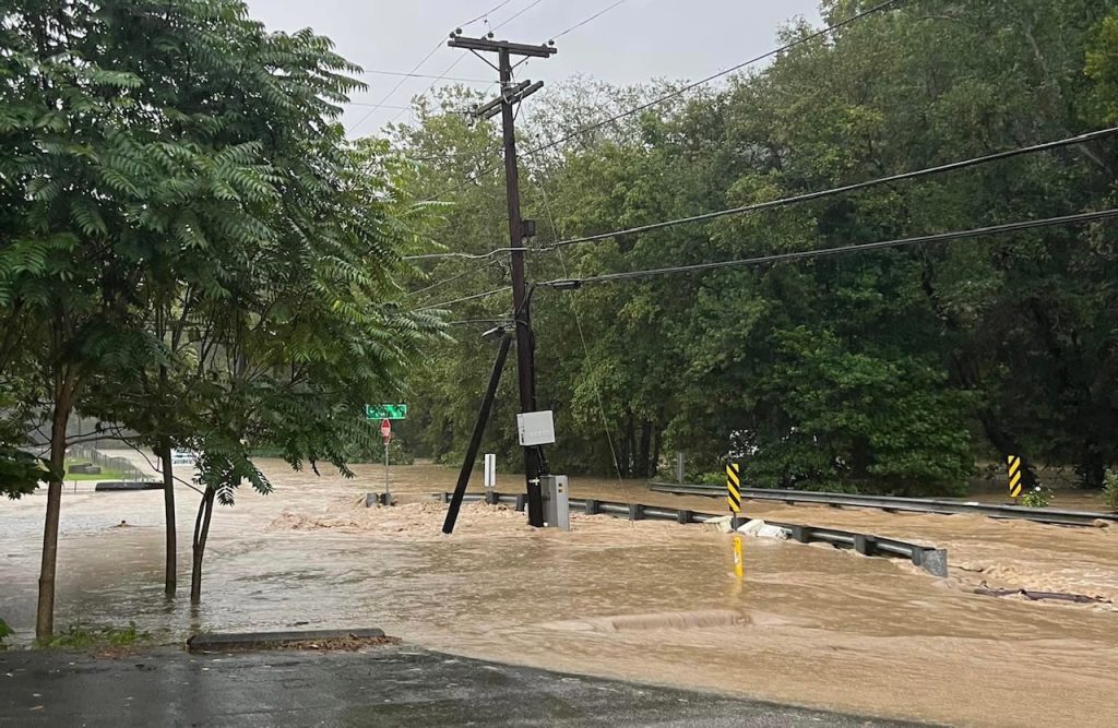
Flooding throughout the day caused significant damage to roads, houses and bridges in central and southern West Virginia.

There have been no deaths reported so far due to flooding. Officials are still working to assess damage. Many houses were flooded and some were washed away.

Communities along Witcher Creek, Slaughter Creek and Fields Creek saw some of the most significant flooding. Waters have  retreated back to creeks and rivers — where flows remain dangerously high. However, with more rain likely this evening and tomorrow, flood advisories remain active.

The National Weather Service said another inch of rain could be on the way Monday night.

Kanawha County Commissioner Lance Wheeler was at the Emergency Operations Center at Kanawha County Metro 911. He said fire departments in Charleston and Fayette and Cabell counties are waiting to see what the weather does, and where the water goes.

“Everybody’s still on standby. They are looking at what water is coming and what it’s going to look like and if there are going to be more evacuations necessary,” said Wheeler.

Wheeler said this amount of rainfall — 6-9 inches in affected areas — coupled with already saturated soil from a rainy weekend made the floods an especially dangerous situation.

“So, the flooding has been enormous at this point,” he said. “If there’s anyone out there who thinks that this is just a small flood that hit this area, they’re drastically wrong.” 

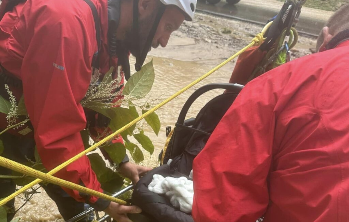
Kanawha County officials say that from 6:45 a.m., when the Kanawha County Metro 911 started receiving calls, until 4 p.m., there were more than 700 calls and 22 water rescues. Assessors have not released official numbers, but Wheeler said that around 60 homes were washed away in the floods.

Jenna Sigmon lives along one of the most heavily flooded creeks, Slaughter Creek, and said she is used to floods, but this one is one of the worst she has ever seen.

“It was like kind of crazy, because we just woke up this morning and there was massive floods,” she said. “And the water came up over the bank all into our yard.”

Her house was flooded. Sigmon went over to a neighbor’s house across the road to get away from the water, but the water ended up crossing the street over to that house as well.

“It just kept rising and rising. Like two feet within ten minutes,” said Sigmon.

The water did eventually recede, but her yard and others around were bogged with water. She said she was expecting a flood, but not one this bad.

If you or anyone you know needs assistance escaping flooding, call 911 or (304) 348–8111 to reach the Metro 911 Emergency flood line.

Original Post: Flash Flood Emergency Declared In Several W.Va. Counties

The National Weather Service Monday issued a flash flood emergency for Kanawha County that is considered life threatening. It also issued flash flood warnings for parts of Braxton, Calhoun, Clay, and Roane counties. The National Weather Service says residents should seek higher ground and avoid flooded areas.

Gov. Jim Justice declared a State of Emergency in those counties. Heavy rainfall over the weekend and throughout Monday morning has caused flash floods that have damaged homes, roads, and bridges in affected areas. There are reports of high water along Witcher Creek in eastern Kanawha County.

The West Virginia Emergency Management Division has implemented an emergency plan to mobilize appropriate personnel and resources to respond to the emergency. 

The National Guard is working to prepare for emergency dispatch with arial assets like helicopters, swift water rescues teams, and extra personnel. Kanawha County’s Emergency Operations Center is actively working to assist with water rescues and other emergency assistance. 

The West Virginia Division of Highways is working to assist residents and clear the road from culverts, mudslides, and other damage from heavy rains throughout affected counties. Mudslides closed both lanes of US 60 in Belle and on the West Virginia Turnpike near Chelyan at Mile Marker 85.5 where the southbound right lane is closed.

FEMA, local officials, and other organizations are also working to offer aid to residents needing assistance.

Exit mobile version