
Escaping The Flood
Anna Goodnight’s yellow panel house sits along the Little Creek hollow. Her home, and the other homes on this street, are accessible by a small bridge that crosses a trickling creek. The morning of August 28th she stood along the side road holding her son’s hand, waiting to put him on the bus. It was raining and had been raining on and off for a couple days.
At 6:45 a.m. Anna looked up the road and noticed the small creek was the slightest bit higher than normal.
“I looked up the road and I called their dad. I said, are you sure everything’s still good? Yeah, (he said) sure. I said, Are you sure? Are you sure everything’s gonna be okay? He said yeah, everything’s fine,” Goodnight said.
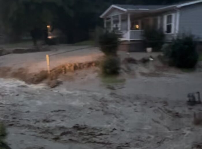
Moments after she ended the call the river had breached its five-foot banks. She looked up stream and saw waves of turbulent water coming towards her.
“It literally looked like the dam opened and all this just came gushing down,” she said.
The bridge that connects the road to their house was washed away creating a cascade of thunderous sounds as bridge after bridge gave way to the pressure of the raging creek.
Anna ran over the bridge, back to her house to grab her other child and her dogs. Then back over the bridge through a veil of water that was coming up over it, to her car.
“As soon as we got across it wiped the whole thing out. When I got in the car to leave, you can see, it followed us all the way down. Just rushing out,” Goodnight said.
Another one of her neighbors was not able to cross the creek in time. Goodnight says she saw her on the other side of the flooding creek climbing with her four young children up over the mountain to get to high ground away from the waters.

Mountains Of Water
The residents in this area are used to floods because these hollows, or areas low in a valley lined up with creeks, are vulnerable to flash floods. However, residents that live along Little Creek all said this flood was different.
“Never have I witnessed anything like that,” Goodnight said.
A flood warning was not issued until 7 a.m. — 15 minutes after Goodnight said the flood started.
“A statement was made from somebody, ‘When you get an alert, that you need to leave your home.’ Well, there was no alert. There was no warning. There was not a flood warning. There was nothing,” Goodnight said.
Most residents say as quickly as the water went up, it went down. That’s characteristic of a watershed area that has been impacted by surface mines, said Nicolas Zegre, a professor of forest hydrology at WVU’s mountain hydrology laboratory.
“When we get into surface mine systems, because of all the impervious surfaces and the lack of vegetation and lack of soils, we see a very flashy flow response where the stream rises very quickly. It peaks very quickly, and then it falls very quickly. And that shape of the hydrograph does say a lot about what’s going on in that watershed,” Zegre said.
In an undisturbed watershed, different things happen to the precipitation, Zegre said. Some of it is absorbed by the ground and stored for later use, some of it absorbed by trees and used in a process called transpiration, some of it is held in the ground or puddles and eventually evaporates. He said even if that water does eventually find its way into the creek, it typically releases the water over a longer period of time, having less intense peaks.
“The biological system that normally would attenuate that rainfall is no longer there. So, we would expect increases in runoff on landscapes,” he said.
Moving Mountains
Reclaimed mines don’t do much better.
“The big question as to whether reclamation ever restores the function of the watershed: The answer is no,” Zegre said.
That’s because those mines, even when complying with state and federal law, usually just plant exotic grasses on top of the minded areas.
“So this requires, you know, built infrastructure to kind of manage the runoff that’s coming off of these impervious surfaces that are associated with the mine. So even when it’s recreated, it’s still a disturbed landscape that is largely dominated by minerals and rocks, as opposed to soils and trees,” Zegre said.
The areas that were flooded are wrapped with older spiraling contour mines and dotted with newer mountaintop removal mines. Mountaintop removal mines are the most common form of modern coal mining.
“It’s really efficient. And so what this does is it starts at the top of the mountain, it removes the trees, it removes the soils, and then it uses explosives to remove the geologic overburden on top of those coal seams,” Zegre said.
Geological overburden is an industry word for a million pieces of blown-up rock that once formed the top of a mountain. That rock is then placed in the valleys to create another industry word, “Valley Fills.”
Some experts, like Zegre, say valley fills store water.
“Research that we’ve done on this has shown, at least for the Coal River watershed in the southern coalfields in West Virginia, maximum flows have been decreasing in that watershed,” he said. “And it was our belief that that was associated with the valley fills.”
However, Zegre says that it is hard to say if those valley fills help absorb torrential rainfall — like the 11 inches of rain that eastern Kanawha County saw in late August.
Other experts like whistleblower, expert witness, activist, and mine and health safety expert Jack Spadaro say valley fills make floods worse.
“All the studies that have been done by hydrology engineers with knowledge about how runoff happens on a slope or a mountain top have proven beyond a question that valley fills do not reduce the flow of water what-so-ever,” Spadaro said. “That’s a myth that was created by the industry to justify what they are doing.”
It’s important to emphasize that with the amount of rainfall that eastern Kanawha County had there would have been a flood regardless, Zegre said.
“Whether it’s an old growth forest, a surface mine, or a parking lot, when you drop 8 to10 inches over a couple of hours, there’s going to be a flood that comes off that landscape,” Zegre said.
Spadaro said while that is true, surface mines make floods worse, whatever the scenario.
“There have been many studies that show there’s an increase of peak discharge during a storm period. It can range between a 150 percent increase to as high as a 1,000 percent increase in the flow of water that’s coming off those watersheds. And that’s what’s been causing these floods,” Spadaro said.
Rising Water, Climbing Temps
As temperatures rise due to climate change, the air holds more water making heavy rainfalls happen more often.
“For every one-degree temperature change in the atmosphere, the atmosphere can actually hold 4 percent more water,” Zegre said. “A study by Climate Central actually showed in Huntington, West Virginia, hourly rainfall has increased by about 28 percent Since the 1970s. And so in an hour, when it’s raining, there’s 28 percent more moisture in the air that’s falling.”
That could account for some of the relentless rain that fell on the watersheds of Fields, Little, and Slaughter Creek Sunday night through Monday morning.
The Hollow Way
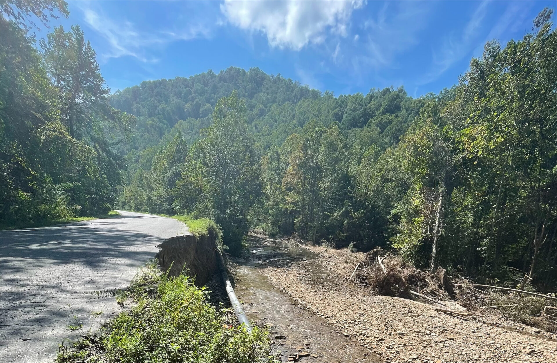
Just a few miles beyond those communities devastated by flash floods, upstream of the creeks that washed out the land, near their headwaters, sits a sprawling active coal mine.
“I think it would be hard to exclude that surface mine from playing a role in the stream flow that was experienced downstream. I would expect that the surface mine played a role in stream flows downstream,” said Zegre. “Now, whether that was enough to create the floods that were experienced, hard to say, but I wouldn’t be surprised.”
Downstream from that mine, sandwiched between two steep green slopes is the Little Creek Hollow where Anna Goodnight and her family live. The effort to clean up the destruction those raging waters left behind has begun. The street is lined with piles of soggy personal belongings waiting to be picked up by debris clean-up crews.
“We lost pretty much everything in the garage. I don’t even know how many feet of mud are probably under the house – around 18 inches,” Goodnight said. “We hooked up our own water yesterday to finally get water because we have had no resources up here whatsoever. No resources. There have been NO resources here.”
Goodnight said she called the Department of Environmental Protection, the Red Cross, the Salvation Army, FEMA, and the Governor’s office to no avail.
“The state and local government have completely let us down on this,” she said.
Frustration in this hollow is balanced with helping each other pick up the pieces. Many who lost their homes are at other neighbors’ houses helping them. Every house had a neighbor or church group there helping gut the water saturated walls, carrying groceries down through the steep creek, baby sitting, lending equipment, or just lending an ear.
That was the case for John Chambers and his sister. They had just put their childhood home on the market when the flood came through.
The kitchen with tile floors is now an empty room with bare sheetrock, water marked plywood, and exposed pipes. Chambers said he had just started working on his own house because he had been helping others
“I got mud and water there. They got 14-15 inches of mud. Got their doors pinned and blown open and can’t walk in the house,” said Chambers. “What are you gonna do? You’re just gonna stand there and watch them with a shovel? No, you’re gonna get out and you’re gonna help! You’re gonna do what’s right!”
The creek bed, the streets, everyone’s yard’s and most people’s homes are filled with this deep yellow, sandy, silty mud — and lots of coal scattered around the area.

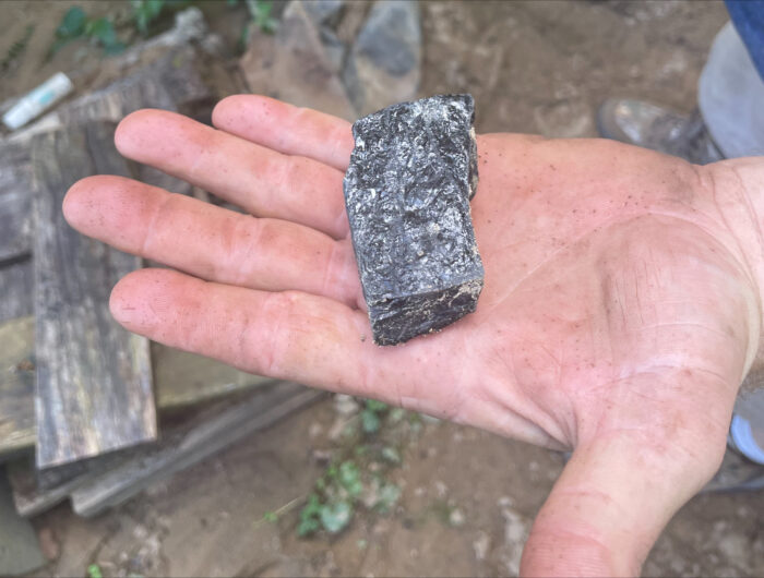
Goodnight walked around her house picking up little pieces of coal.
“There’s coal in my garage, coal in the backyard, I mean it’s everywhere,” Goodnight said.
Little pieces giving way to more questions. his reason, or that reason.
“Not to say blame needs to be placed, but I need a little peace of mind,” Goodnight said.
Community members and leaders are urging for an investigation into surface mines in and around eastern Kanawha County. And this community is searching for answers – how did this happen? Why was it so bad this time? Was it surfacing mining? Climate change? Timbering? A sediment pond? And an act of God?
“I wouldn’t say it’s an act of God. God wouldn’t do this to people,” Chambers said.


