Justice Declares State Of Emergency, Sweeping Storms Cause Power Outages

A powerful line of storms rolled across West Virginia on Tuesday, knocking down trees and powerlines. The storms brought power outages for more than 100,000 residents across the state.

This is a developing story and may be updated.

Updated on Tuesday, April 2, 2024 at 3:20 p.m.

Gov. Justice has declared a State of Emergency for Fayette, Kanawha, Lincoln and Nicholas counties Tuesday due to severe thunderstorms with high winds, which caused flooding, downed trees, power outages, and road blockages.

The declaration is a proactive measure ensuring the allocation of necessary resources and expedition of emergency response efforts. The State of Emergency allows State and Local agencies to take swift and decisive actions to mitigate the impact of the storms and protect the lives and property of West Virginians.

Original Story: Sweeping Storms Spur Tornado Watch, Power Outages

A powerful line of storms rolled across West Virginia on Tuesday, knocking down trees and powerlines.

According to the National Weather Service, several rounds of thunderstorms are expected to continue into the night.

The storms could also bring “damaging winds, large hail, flash flooding and tornadoes,” the National Weather Service reported.

Storms will hit central West Virginia between 4 and 9 p.m. and move east.

In response to the storms, Marshall University closed its campuses for the remainder of the day Tuesday afternoon.

In West Virginia, storms knocked down trees and powerlines throughout Tuesday, bringing tornado and thunderstorm advisories to counties across the state.

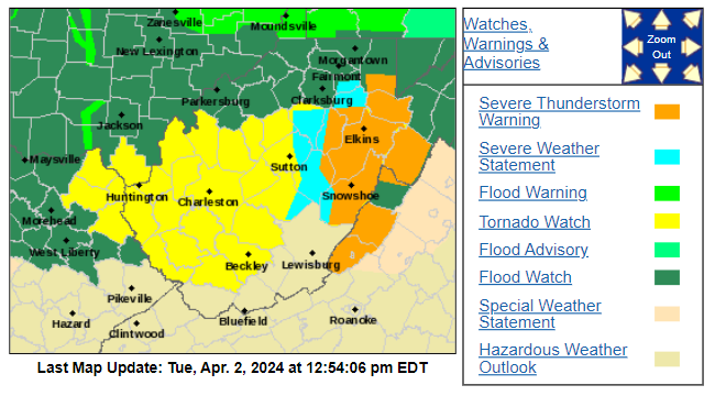
Graphic Credit: National Weather Service

Emergency alerts and sirens sounded across Kanawha County Tuesday morning, as thirteen counties in southwestern West Virginia were placed under a tornado watch.

The Kanawha County Commission issued a state of emergency over the storms Tuesday afternoon. In a press release, the commission said 911 dispatchers had received more than 500 calls regarding the tornado warning that morning.

“Metro received calls regarding structure collapses, entrapments, vehicle wrecks, fires, fallen trees, and many medical calls,” the press release read. “There [have] been reported touch downs of tornadoes in the western portion of the county, but no confirmation at this time.”

As of 12:30 p.m., Appalachian Power reported 118,000 power outages, 53,000 of them in Kanawha County alone.

The commission urged Gov. Jim Justice to issue Kanawha County a state of emergency over the weather.

For additional updates on the storms, visit the National Weather Service website.

Fire Danger High Due To High Winds And Warm Temperatures

The National Weather Service warns low humidity will be above normal temperatures and dry fuels will combine with gusty winds to create a heightened danger of wildfire ignition. They say this has the potential to spread through this evening. 

The National Weather Service has issued a Special Weather Statement in coordination with the West Virginia Division of Forestry.

The weather service warns low humidity will be above normal temperatures and dry fuels will combine with gusty winds to create a heightened danger of wildfire ignition. They say this has the potential to spread through the evening. 

Spring fire burning laws are not yet in effect, but with several brush fires reported, the public is cautioned against open burning of any type at this time. It is also advised that people exercise caution with heat and sparks while operating any equipment or smoking in wildland areas.

The Special Weather Statement is in effect until 7 p.m. EST with the following counties included:

Wayne, Cabell, Mason, Jackson, Wood, Pleasants, Tyler, Lincoln, Putnam, Kanawha, Roane, Calhoun, Ritchie, Doddridge, Mingo, Logan, Boone, McDowell, Wyoming, Upshur, Barbour, Raleigh, Fayette, Nicholas, Webster, Pocahontas and Randolph counties.

The National Weather Service indicates high winds throughout the day and into the evening.

“We have strong gusty winds that have developed across the area,” said Simone Lewis, meteorologist with the Charleston branch of the National Weather Service. “In addition to the fact there’s a very dry air mass in place, there’s a lot of dry, dead vegetation left over from the winter, that, along with the wind, has led to really dry conditions and an increased fire threat.”

Winter Weather on It's Way

The National Weather Service has issued a winter storm watch for most of the state Tuesday into Wednesday as a Nor’easter makes its way across the mid west and into the northeast.

Meteorologist Ken Batty of the NWS said much of the state will experience light to moderate rain showers throughout the day Tuesday that will increase into the evening hours.

The northern panhandle is the exception as they are experiencing colder temperatures already bringing them snow. Areas near Wheeling and Weirton will continue to see snowfall throughout the day Tuesday into Wednesday.

The forecast is expected to change overnight, however, as cold air moves into West Virginia.

“The colder air will rush in tonight and change the participation from rain to snow, say, in the tri-state around Huntington and in the Ohio River counties like Parkersburg to Huntington before midnight,” Betty said.

“Then, it will reach the southern coalfields and the I-79 corridor from Charleston to Morgantown late tonight,” he added. “Everybody should be involved in wind blown snow and snow showers on Wednesday.”

Batty said Tuesday’s evening commute will consist of steady rain, but snow will accumulate by morning making for a slower travel.

Accumulation overnight and into Wednesday could total in the double digits in the northern panhandle and mountain counties with 5 to 10 inches expected in the central lowlands and southern coalfields.

Only flurries are expected in the eastern panhandle.

Batty expects most of the precipitation to finish by tomorrow morning, making for fair travel conditions Wednesday afternoon and into Thursday.  
 

Severe Thunderstorm Watch Issued in Addition to Wind Advisory

Update: Sunday, November 17, 2013 at 9:30

Here’s a roundup of tweets from local and regional authorities, including emergency services and the National Weather Service:

Update: Sunday, November 17, 2013 at 9:14 p.m.

In addition to a wind advisory in effect for most of the state, a severe thunderstorm watch has been issued for the western portion of West Virginia.  The National Weather Service in Charleston reports this watch is in effect until 1 a.m. Monday.

Original Story Published on Sunday, November 15, 2013 at 5:35 p.m.

According to the National Weather Service, a wind advisory remains in place overnight Sunday, Nov. 17, for most of the state until 4 a.m. Monday, Nov. 18.

Credit National Weather Service
/

  Wind gusts up to 50 mph are expected with the strongest periods of wind between 11 p.m. and 3 a.m. The National Weather Service reports winds of this strength can down power lines and possibly trees and can also make driving difficult. Using extreme caution while driving is advised.

Specific advisories, including times by area are listed below. Advisories are as of 5:30p.m. Nov. 17:

Greenbrier; Mercer; Summers
Issued: November 17 at 4:00PM EST
Expiring: November 18 at 6:00AM EST  

Brooke; Hancock; Marshall; Ohio; Wetzel
Issued: November 17 at 3:34PM EST
Expiring: November 18 at 7:00AM EST

Marion; Monongalia
Issued: November 17 at 3:34PM EST
Expiring: November 18 at 7:00AM EST

Preston; Tucker
Issued: November 17 at 3:34PM EST
Expiring: November 18 at 7:00AM EST

Barbour; Boone; Braxton; Cabell; Calhoun; Clay; Doddridge; Fayette; Gilmer; Harrison; Jackson; Kanawha; Lewis; Lincoln; Logan; Mason; Mingo; Nicholas; Pleasants; Pocahontas; Putnam; Raleigh; Randolph; Ritchie; Roane; Taylor; Tyler; Upshur; Wayne; Webster; Wirt; Wood
Issued: November 17 at 2:34PM EST
Expiring: November 18 at 4:00AM EST

McDowell; Wyoming
Issued: November 17 at 2:34PM EST
Expiring: November 18 at 4:00AM EST  

Eastern Grant; Eastern Pendleton; Hardy; Western Grant; Western Mineral; Western Pendleton
Issued: November 17 at 12:35PM EST
Expiring: November 18 at 6:00AM EST


Exit mobile version