Thousands Of Acres Burn As Dry Weather Continues

Seventy-five fires have set an estimated 16,000 acres, or 25 square miles ablaze statewide, Gov. Jim Justice said in Wednesday’s briefing. 

Seventy-five fires have set an estimated 16,000 acres, or 25 square miles ablaze statewide, Gov. Jim Justice said in Wednesday’s briefing

Many of the fires are in the southern region of the state. 

According to the National Weather Service, improperly extinguished leaf burns that grew out of control caused many of the fires. The National Weather Service said the warmer sunny weather and dry conditions have exacerbated the fires. Justice warned residents to take special caution due to the weather patterns. 

“It has been incredibly dry the last 30 days. So with all that being said, please, please, please be careful,” Justice said. “You know, the fall fire season is in effect until Dec. 31. It’s essential to all West Virginians to be aware of, and to follow, the necessary regulations to prevent wildfires, because it can get really bad, really bad.”

According to the National Weather Service, a wet front is expected to move in Thursday or Friday, which will curb fire growth. However, until precipitation begins, the land is susceptible to fire and any burning should be practiced with caution, Justice said. 

“It’s so simple just, you know, burning trash or whatever in your backyard. And all of a sudden, you know, a spark gets loose, and it goes into a back woodlot,” Justice said. 

Trash burning is illegal in West Virginia. Leaf burns are permitted from 5 p.m. to 7 a.m. and must be properly extinguished.

After Devastating Floods, Small Communities Take Steps Toward Recovery

Sigman said the quick response from residents, first responders, and state and local officials resulted in better outcomes for the safety of residents. The National Weather Service said it received its first call about flooding at 6:45 a.m. By 7a.m. a warning had been issued and sirens were activated.

The recovery and assessment process began Tuesday in eastern Kanawha County where floods damaged homes, vehicles, bridges, and roadways. 

On Wednesday the Kanawha County Commission reported that at least 78 homes were affected, three were destroyed, and seven remain inaccessible according to a survey the commission issued. The commission expects this number to rise as more residents complete the survey, many of whom live in the areas most severely affected.

There were no fatalities from the flood. Emergency Management Director CW Sigman said that’s mostly due to residents making good choices by not attempting to cross streams.

“I know, it was a very scary time for the folks to be in houses with water rushing in back,” said Sigman. “I talked to one lady who had grandchildren on the opposite end of the road she’s on and she was just in tears because she was worried about her grandchildren. But they didn’t get out into the high water and that saves lives.”

Sigman said the quick response from residents, first responders, and state and local officials resulted in better outcomes for the safety of residents. The National Weather Service said it received its first call about flooding at 6:45 a.m. By 7a.m. a warning had been issued and sirens were activated.

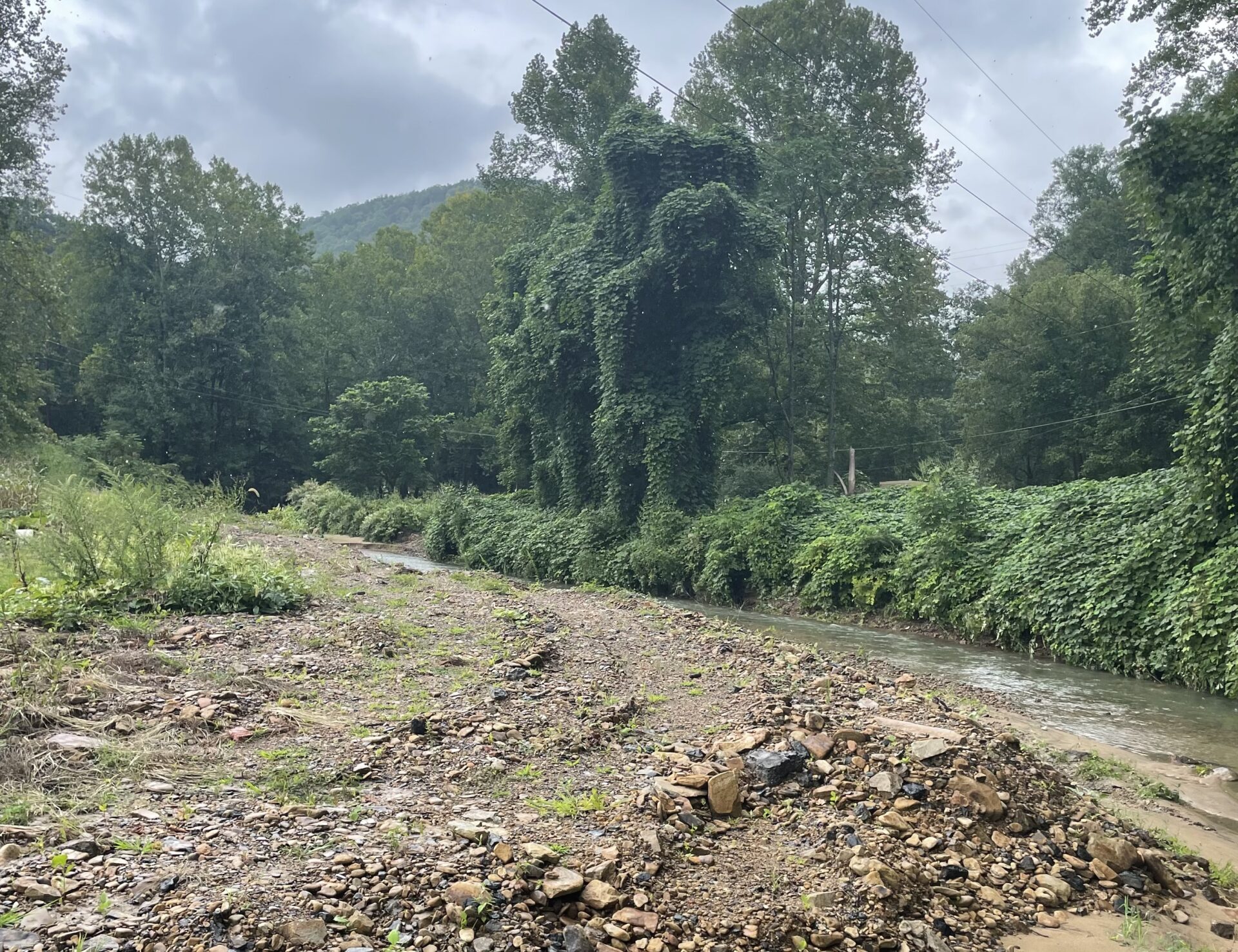
The flood flashed quickly, many residents said that it rose faster than any other flood they had seen — rising feet in a matter of hours.

Fast Moving Water Is Powerful

Sigman says that many of the streams that saw the worst flooding like the Slaughter Creek watershed had steep gradient streams. The water moved quickly down into valleys where residential communities live. Sigman says that the water, sediment, and debris it brought with it caused lasting damage to the creek bed and banks.

Sigman visited one of the affected homes where he was told the homeowners had just made their first mortgage payment. The creek behind the home had eroded so severely that it had moved 10 feet closer to their home — possibly putting it at a higher flood risk for future storms.

“That kind of damage is disturbing with how much sediment came with it and how much the creek banks and the hillsides have caved in,” Sigman said.

Water Quality Affected

As water moved through the hills, it collected debris, sediments, bacteria, and chemicals. The Kanawha-Charleston Health Department has detected E. Coli in a residential water well that was tainted during Monday’s floods.

The Health Department is encouraging residents to have wells tested for free to avoid ingesting the deadly strain of bacteria.

“I hope this information gets out to residents who clearly have so much going on in their lives right now. We really don’t want an emergency room visit for a E. coli infection to be one more ordeal they have to contend with right now,” said KCHD Health Officer Dr. Steven Eshenaur.

Many of the areas where the rain fell have been heavily mined, which could also affect the quality of the water. A study published in the Journal of Hydrology said that water discharged from active or inactive coal mine sites has higher acidity and can contain heavy metals.

Insurance Payouts And FEMA Disaster Declaration For Small Communities 

State and local officials are working to assess damage to homes and infrastructure. Once the process is complete, the localities will send numbers to the governor who can then request a FEMA disaster declaration.

Sigman says there are multiple qualifiers that FEMA is looking for to declare a disaster declaration. For example, the state must meet a threshold of $3 million in damage to infrastructure.

“They look at vulnerability factors. You know you live in an area that has a lot of retired citizens, people with disabilities or other vulnerability factors, FEMA will factor that in,” Sigman said.

Sigman said that FEMA is in place to help a community though the crisis but usually does not work to replace homes or rebuild infrastructure.

Local Response And Plan

The Kanawha County Commission has worked with other agencies and community members to assist flood victims. They are still accepting donations, and say they specifically need contractor grade trash bags, bleach, push brooms, and shovels. They do not accept clothing or cash donations. Supply Distribution points are at Belle Town Hall and Chesapeake Town Hall.

On Tuesday, Curbside Debris Collection will begin in Slaughters Creek, Winifrede-Fields Creek, Witcher Creek, Kelly’s Creek, and Horsemill Hollow. The Kanawha County Planning and Development Office is asking that debris be placed off Private Property, onto the road. The office also asks that residents report damage so that official recovery processes can begin.

National Weather Service: Expect Rain, Wind From Remnants Of Hurricane Laura Starting Late Friday

The remnants of Hurricane Laura are expected to make their way across West Virginia late Friday evening and into early Saturday morning, according to federal weather forecasters. 


The National Weather Service said the storm, which made landfall as a Category 4 hurricane along the Gulf Coast in Cameron, Louisiana, is expected to be significantly weaker when it travels through the Mountain State. 


West Virginians, especially in the southern parts of the state, can expect wind gusts up to 20-30 miles per hour. However, rainfall associated with the storm is the main concern, said Dave Marksalek, a meteorologist with the National Weather Service in Charleston. 

“Wind shouldn’t be the biggest factor with this,” he said. “It’s going to be the rain that it brings to the region.”

The NWS predicts Laura will bring 1-2 inches of rain to parts of the state. However, much of West Virginia has already seen rainfall in recent days. 

On Thursday, the NWS reported 3 to almost 5 inches of rain fell in far northern Clay County, northern Nicholas County, and southern Braxton and Webster counties prompting some reports of flash flooding. 

More storms are expected today as well as late Saturday, after the remnants of Laura pass through.  

Marksalek said storm activity before and after Laura sets up parts of West Virginia for possible flooding. 

“If we get more areas across the state that receive a lot of rain from the showers and storms today, before Laura arrives, it can create some additional problems as Laura moves through,” he said. 

Marksalek said so far it appears the remnants of Laura are moving quickly, and he expects the system to pass through West Virginia in a matter of hours. 

Spring? Heavy Snow Falls in West Virginia, Kentucky

Updated on Wednesday, March 21, 2018 at 12:25 p.m.

It might be spring, but areas of West Virginia and Kentucky look more like winter, especially at ski resorts, with up to a foot of snow forecast in some areas.

The National Weather Service issued a winter storm warning for the eastern half of West Virginia until 11 p.m. Wednesday and in areas around Louisville, Kentucky, until 2 p.m. Much of the rest of both states were under a winter storm advisory that called for up to 5 inches of snowfall.

Snow fell Tuesday night and continued Wednesday afternoon, making travel difficult in some areas and leading several school systems to cancel classes.

Residents in some snow-bombarded areas of West Virginia were told to stay off the roads to allow crews to treat them.

Joe Castaldo, the state Department of Transportation’s Berkeley County supervisor, told the Journal of Martinsburg that numerous vehicles have slid off roads or become stuck on hills.

Castaldo suggested that people stay home if they can.

“If they have to be out, then try to stick to main primary routes and only go if you have four-wheel drive vehicles,” he said.

FirstEnergy said nearly 10,000 customers in northern and eastern West Virginia were without electricity on Wednesday, while Appalachian Power said more than 7,000 customers were without service in southern West Virginia.

In Louisville, Kentucky, heavy, wet snow fell at the rate of about an inch per hour, snapping tree limbs. Kentucky Transportation Cabinet spokeswoman Andrea Clifford said crews were salting and plowing roadways.

For some areas that have dodged snowfall this winter, it was the first major storm.

Sarah Schottler, who runs Blakeley Street Bakery in West Virginia’s Eastern Panhandle community of Charles Town, said a vendor show in Maryland where she was supposed to promote her products was canceled by the storm, but that freed her up to get some Easter cookie orders filled at her shop. Her two children got a snow day off from school Wednesday after about 8 inches of snow fell. More was still coming down.

“It’s definitely our only one for the year,” Schottler said. “I feel like a lot of people were kind of OK with it because you spend all winter wondering if we’re going to get any and we really didn’t get anything. And you know it’s the last one. So it’s like the light at the end of the tunnel.”

Some of West Virginia’s ski resorts are enjoying an early spring surge after a warm February, said Joe Stevens, spokesman for the West Virginia Ski Areas Association.

The storm has especially benefited a pair of cross country ski areas. Whitegrass Touring Center in Tucker County and the Elk River Touring Center in Pocahontas County should “finish the season strong with excellent conditions,” Stevens said.

During an eight-day stretch in mid-March, 70 inches of snow fell at Snowshoe Mountain Resort, and that was before the current storm hit. The resort had 40 of 60 trails open Wednesday and plans to keep them open through the end of the month.

The storm came too late for skiers hoping to get in one last run at Timberline Four Seasons Resort and Canaan Valley resort, which had already shut down its slopes. In southern West Virginia, Winterplace Ski Resort suspended operations after last weekend and plans to decide whether to re-open for slopes this weekend.

Several West Virginia Cities Set Marks for Warmest April

The National Weather Service says last month was the warmest April on record in several West Virginia cities.

The weather service says Beckley, Clarksburg, Elkins and Parkersburg all set records for the average temperature during the month, while Charleston and Huntington each had their second-warmest Aprils on record.

Clarksburg’s average temperature of 58.2 degrees surpassed the previous mark of 56.7 set in 1954.

Beckley broke a record set in 2011, Elkins broke the mark set in 1954, and Parkersburg surpassed the record set both in 1896 and 1954.

Exit mobile version