Severe Weather Covers The State, IDD Waivers Cut From Budget, And Warmer Weather Brings Out Cyclist

On this West Virginia Week severe weather pounded the state, from destructive tornadoes in the south to historic floods in the north. 

On this West Virginia Week, severe weather pounded the state, from destructive tornadoes in the south, to historic floods in the north. 

Jobs in the state saw some losses, and some possible wins, while a program for people with disabilities was cut from the recent Budget. Chris Schulz takes listeners on a bike ride through the hills of Morgantown. 

Also, Friday marked the 14th anniversary of the Upper Big Branch Mine disaster. Briana Heaney sat down with former WVPB reporter Ashton Marra to discuss her reporting on the trial that followed the disaster. 

Brina Heaney is our host this week. Our theme music is by Matt Jackfert.

West Virginia Week is a web-only podcast that explores the week’s biggest news in the Mountain State. It’s produced with help from Bill Lynch, Briana Heaney, Chris Schulz, Curtis Tate, Emily Rice, Eric Douglas, Jack Walker, Liz McCormick and Randy Yohe.

Learn more about West Virginia Week.

Active Duty And Retired Military Eligible For Emergency Prescriptions Due To Storms

Uniformed service members, military retirees and their families served by TRICARE are eligible for emergency prescription refills due to recent inclement weather.

The Defense Health Agency announced Thursday that TRICARE beneficiaries in four counties in West Virginia may receive emergency prescription refills now through April 13, 2024, due to storm damage.

The Defense Health Agency and TRICARE serve uniformed service members, military retirees and their families. 

Beneficiaries in Fayette, Kanawha, Lincoln and Nicholas counties are eligible for the emergency waiver.

On Thursday afternoon, Gov. Jim Justice amended his State of Emergency to include Barbour, Brooke, Hancock, Marshall, Ohio, Wetzel and Wood counties. 

The Defense Health Agency told West Virginia Public Broadcasting via email that the waiver will not be extended to those counties at this time.

To receive an emergency medication refill, TRICARE beneficiaries should take their prescription bottle to any TRICARE retail network pharmacy. Patients are advised to visit the pharmacy where the prescription was originally filled.

To find a network pharmacy, beneficiaries may call Express Scripts at 1-877-363-1303 or search the network pharmacy locator.

National Weather Service: Tornado Touched Down In Fayette County

Preliminary damage assessments indicate an EF-2 tornado, with wind speeds up to 130 mph, touched down in the Hico area during Tuesday’s severe weather.

The National Weather Service said a tornado touched down Tuesday in Fayette County.

Preliminary damage assessments indicate an EF-2 tornado, with wind speeds up to 130 mph, touched down in the Hico area during Tuesday’s severe weather.

John Peck, a meteorologist with the National Weather Service in Charleston, explained how the tornado’s strength is calculated.

“Structures, depending on how the structure is built, what the structure is made of, tree damage, things like that,” he said. “We generate an estimated wind speed based off the damage to those indicators.”

No fatalities have been reported statewide from Tuesday’s storms. 

The deadliest tornado in state history occurred in Shinnston on June 23, 1944. It killed 103 people and clocked wind speeds of 206 mph. Today, it would be categorized as an EF-5, the strongest possible tornado.

Tornadoes are ranked according to their wind speeds, from EF-0 at 65 mph to EF-5 at 200 mph. Anything EF-2 or above is considered strong.

Peck said West Virginia sees, on average, one tornado a year.

This week marks the 50-year anniversary of the 1974 Super Outbreak of 148 tornadoes in 13 states in the Midwest and South, killing 335 people.

Though West Virginia was not as severely affected as Kentucky or Ohio in April 1974, a few tornadoes did touch down in southern West Virginia.

Air Quality Advisory Likely To Move On Before Severe Weather

The West Virginia Department of Environmental Protection issued a statewide air quality advisory for fine particulate matter through Monday at midnight. There is a possibility for severe weather across the state through Thursday.

The West Virginia Department of Environmental Protection (DEP) issued a statewide air quality advisory for fine particulate matter through Monday at midnight. As with previous air quality incidents this summer, the source are wildfires in Canada.

Nick Webb, a meteorologist for the National Weather Service in Charleston, said storms moving through the state might bring temporary relief.

“I don’t think it would last before [the smoke] would move back in,” he said. “Essentially, the rain would help bring that particulate matter down to the ground level almost.”

Webb said the smoke and haze should start to clear up Tuesday as winds shift to blow east.

“Any sustained relief, that’s going to depend on the wind direction in the upper levels of the atmosphere,” he said.

There is a possibility for severe weather across the state through Thursday.

“Today is a slight risk for severe weather with damaging winds being the main threat along with torrential rainfall,” Webb said. “Probably the more significant system we’re looking at is Wednesday and Thursday that right now looks to affect mainly the southern half of the state.”

Severe Weather Moves Into The State 

Thunderstorms during the afternoon and evening have the potential to produce damaging winds and large hail, as well as heavy rainfall which could lead to minor flooding.

The eastern half of the state is under a hazardous weather outlook Monday afternoon and through the night. Thunderstorms during the afternoon and evening have the potential to produce damaging winds and large hail, as well as heavy rainfall which could lead to minor flooding.

“Some of these storms could produce some very heavy rain, to the tune of maybe as much as an inch, inch and a quarter in an hour’s time frame,” said National Oceanic and Atmospheric Administration meteorologist Lee Hendricks. 

This storm system has battered the Great Plains region in recent days with deadly tornadoes and large hail.

Hendricks said although the worst of the system has moved well up into the north and weakened, there’s still a possibility of some isolated, severe weather.

“With any incoming weather system like this, with thunderstorms involved, you need to have a little bit of situational awareness of what’s going on, what’s expected to go on and pay attention,”  he said.

Hendricks said tonight’s storms will usher in a week of potential thunderstorms and milder temperatures.

“We’re looking at really only one day that we can honestly say you’re going to have sunny, dry weather and that’s going to be on Thursday,” he said. “Other than that, we’re going to have a chance for a shower or thunderstorm in the forecast pretty much through this coming Sunday.”

West Virginians Advised to Watch Out for Hurricanes

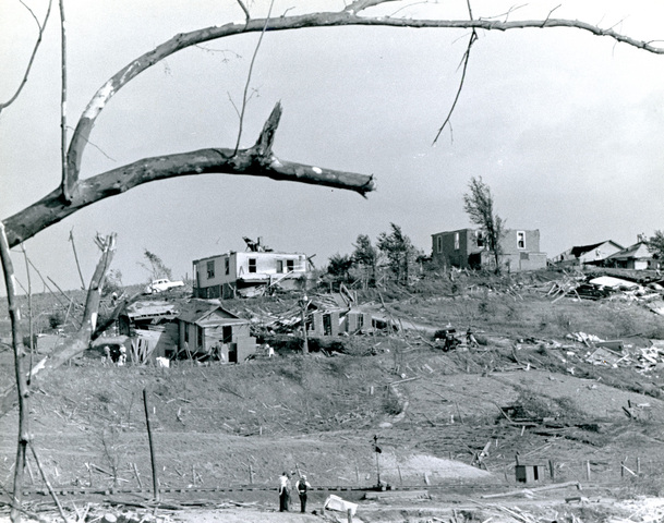
State authorities are urging West Virginians to prepare for the upcoming hurricane season, even if they’re miles away from the nearest coastline. 

During hurricanes, West Virginia often bears the brunt of heavy rainfall, flash flooding, powerful winds, tornadoes and landslides, according to a press release from the state Division of Homeland Security and Emergency Management. 

On Thursday, July 11, the division advised residents to watch out for a tropical storm developing in the Gulf of Mexico that the National Hurricane Center said will become a hurricane by late Friday.

The most recent outlook from the National Oceanic and Atmospheric Administration anticipates nine to 15 named storms in the Atlantic basin hurricane season this year. Four to eight are likely to become hurricanes, with two to four becoming major hurricanes. 

The first named storm of the 2019 season, Subtropical Storm Andrea, formed May 20 and dissipated the following day, the division said. Tropical Storm Barry is developing in the Gulf of Mexico now. 

The rest of the names for the 2019 season are Chantal, Dorian, Erin, Fernand, Gabrielle, Humberto, Imelda, Jerry, Karen, Lorenzo, Melissa, Nestor, Olga, Pablo, Rebekah, Sebastian, Tanya, Van and Wendy. 

In a statement from the division, Director Mike Todorovich said his group and others working for the state “stand ready to respond” to hurricanes and tropical storms. 

“Our greatest priority is keeping our fellow West Virginians safe and being ready to respond and mobilize state assets when needed,” Todorovich said. 

National Weather Service Issues Flood Watches, Warnings 

Credit National Weather Service
/

The National Weather Service in Charleston and Pittsburgh also issued a flash flood watch for West Virginia counties on Thursday. 

Both advisories will last until 8 p.m., Thursday, July 11. In many of these counties the ground is still saturated from recent rain storms, which could lead to faster flash flooding. 

The Charleston-issued watch encompasses Lewis, Harrison, Taylor, Upshur, Barbour, parts of Webster, Pocahontas and Randolph counties. 

The Pittsburgh-issued watch covers Brooke, Tucker, Hancock, Marion, Marshall, Monongalia, Ohio, Preston and Wetzel counties. 

Pittsburgh’s office issued a much more serious flash flood warning for central Preston county and northeastern West Virginia, lasting until 8:30 p.m. 

In a flash flood warning, the National Weather Service has deemed flooding imminent. During a flash flood watch, the National Weather Service reports there are favorable weather conditions for flooding.

Charleston’s flash flood warning applies to portions of Randolph, Lewis, Braxton, Upshur and Webster counties until 5:30 p.m.

Exit mobile version