The National Weather Service expects heat and humidity to move into the Mid-Ohio Valley Thursday and Friday.
This may result in heat index values above 100 degrees, posing a danger for heat related illnesses.
The state’s western counties are under an excessive heat watch through the end of the week.
The National Weather Service expects heat and humidity to move into the Mid-Ohio Valley Thursday and Friday.
This may result in heat index values above 100 degrees, posing a danger for heat related illnesses. The heat index combines both air temperature and relative humidity into a single value of how hot the weather will feel.
Francis Kredensor, lead meteorologist with the National Weather Service in Charleston, said there may be some variability in the coming days, but high heat is all but assured for the region.
“It’s still a little bit of a question just how high it will be, but we’re pretty confident on at least the 100-degree heat index readings, and a good chance that we’ll be above 105 in a lot of spots,” he said.
According to the National Oceanographic and Atmospheric Administration, a heat index between 90 degrees to 103 degrees requires extreme caution. Heat stroke, heat cramps or heat exhaustion are possible with prolonged exposure or physical activity.
Kredensor reminds people to take it easy, especially those with health sensitive on heat issues, and to over exert yourself in any outdoor activity if avoidable.
The extreme heat is expected to be short-lived as cooler air moves into the region Friday evening.
“It doesn’t look like the front itself has a lot of storms forecast to be associated with it, but definitely it could have some storms,” Kredensor said. “The bigger thing will just be getting some cooler and somewhat drier air in from the north and northwest.”
Friday’s outages coincided with a National Weather Service excessive heat warning, which remained in place through 9 p.m.
Tens of thousands of Appalachian Power customers lost electricity Friday after a powerful line of storms ripped through the southern half of West Virginia.
As of 6:15 p.m., about 51,000 of the company’s customers in multiple West Virginia counties were without power.
Phil Moye, a spokesman for the utility, said the “vast majority” of the outages were due to storm activity. Moye added there was a possibility of strong winds and storms on Saturday.
Friday’s outages coincided with a National Weather Service excessive heat warning, which remained in place through 9 p.m.
The counties included Cabell, Mason, Jackson, Wood, Lincoln, Putnam, Kanawha, Roane, Wirt, Calhoun, Ritchie, Logan and Boone.
The warning included portions of northeast Kentucky and southeast Ohio.
These areas could be exposed to extreme heat and humidity, with heat index values of up to 110 degrees. Such conditions increase the potential for heat related illnesses.
A heat advisory was also in place through 9 p.m. for other portions of West Virginia, Kentucky and Ohio.
Appalachian Power is an underwriter of West Virginia Public Broadcasting.
Prolonged exposure to these temperatures can cause complications ranging from muscle cramping and lightheadedness to heat stroke in extreme cases.
Heat and humidity are combining across the state to create dangerous conditions outdoors.
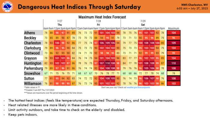
The heat index in some parts of West Virginia reached into the triple digits Thursday afternoon, with temperatures expected to go higher Friday and Saturday.
The heat index combines both air temperature and relative humidity into a single value that indicates the apparent temperature in degrees Fahrenheit, or how hot the weather will feel.
The West Virginia Emergency Management Division announced Wednesday that State and local agencies are on high alert to respond to any heat-related emergencies that may arise.
Dr. Lee Smith, the physician director and county health officer for the Monongalia County Health Department, said prolonged exposure to these temperatures can cause complications ranging from muscle cramping and lightheadedness to heat stroke in extreme cases.
“You should try to avoid the heat,” he said. “Take a lesson from those countries that traditionally have a lot of heat. They have siesta, which is a way to get people out of the heat of the day. You can resume your activities later on in the evening.”
Smith said staying hydrated is an often overlooked necessity in hot conditions, not only with water but with electrolytes as well. He also recommended wearing loose-fitting, comfortable clothing.
“It’s easy to do, (people) wait until they’re thirsty to drink. You really need to try and keep well hydrated, that keeps things moving through the body,” he said. “If you’re doing activities, if your job requires you to be out in the sun, you should be taking things with electrolytes in them because we don’t want you just hydrating with water. You need the potassium and the chlorides and the phosphorus and all that stuff to keep your muscles from cramping.”
High heat events are an important time to check in on elderly relatives and neighbors who, along with young children and individuals with pre-existing health conditions, are more susceptible to the heat.
“In the elderly it’s because many times they’re on medications that make them more susceptible and the young, their metabolism is somewhat different than an adult and they’re more susceptible to heat type of issues,” Smith said. “People need to be aware that they should never leave their pets, their animals or their children inside a car on these hot days because it will heat up hotter inside the car.”
The National Weather Service’s outlook for July 27 through July 29, 2023.
Exposure to extreme heat, even for a short amount of time could be the reason for a deadly heat stroke in children, the elderly and pets.
Exposure to extreme heat, even for a short amount of time could be the reason for a deadly heat stroke in children, the elderly and pets.
Dr. Steven Eshenaur, Kanawha Charleston health officer, urges drivers to be mindful of who is in their backseat during extreme summer temperatures.
“Check your back,” Eshenaur said. “Make sure you don’t leave a child or pet in your car, especially this time of year, they can quickly overheat and we don’t want to see any unnecessary deaths.”
Eshenaur also said dangerous heat and humidity combinations could be fatal, even with the windows cracked, vehicles heat up quickly.
“When the air isn’t moving much, even leaving windows cracked or open, a vehicle can heat up to dangerous levels quickly. Sometimes, it might seem cool enough to us to not be concerned about the inside temperature of a car, but I wouldn’t trust your personal thermostat when it comes to the safety of others on hot summer days. Heat stroke can come on more quickly than you might think,” Eshenaur said. “The temperature inside a vehicle will reach 100 degrees in 25 minutes when the outside temperature is only 73 degrees.”
When a car heats up and the human body reaches a core temperature of 104 degrees Fahrenheit, heatstroke can occur, causing toxins to flood the body, leading to cell death.
According to the National Safety Council, 10 deaths have been attributed to vehicular heatstroke in the U.S. so far in 2023.
On average, 38 children under the age of 15 die this way every year. In 2018 and 2019, a record number of 53 children died after being left in a hot vehicle.
Other precautions to take during hot summer weather:
Dress children in loose, lightweight, light-colored clothing.
Keep kids and pets hydrated. Sugar and caffeine counter that effect.
Find a reminder to check your back seat that works for you. You could keep your purse, wallet, briefcase and phone in the back with the child or pet to help you remember to check back there when in a hurry.
The rain that unleashed massive floods in Appalachian mountain communities was diminishing on Tuesday, leaving survivors to face a new threat: baking in the heat as they try to recover.
The rain that unleashed massive floods in Appalachian mountain communities was diminishing on Tuesday, leaving survivors to face a new threat: baking in the heat as they try to recover.
“It’s going to get really, really hot. And that is now our new weather challenge,” Kentucky Gov. Andy Beshear said at his morning briefing on the disaster.
The death toll stood at 37 on Tuesday after more bodies were found Monday in the ruined landscape, and while more than 1,300 people have been rescued, crews are still trying to reach some people who remain cut off by floods or mudslides. Hundreds were unaccounted for, a number that should drop as cellphone service is restored and people can tell each other they’re alive, the governor said.
“It is absolutely devastating out there,” Beshear said. “It’s going to take years to rebuild. People left with absolutely nothing. Homes that we don’t know where they are, just entirely gone. And we continue to find bodies of our brothers and sisters that we have lost.”
The National Weather Service warned that slow-moving showers and thunderstorms could provoke more flash flooding through Tuesday morning along waterways swollen by Sunday’s heavy rain, a dismal coda to last week’s historic floods. That includes communities just across the state line in Virginia and West Virginia, where some people also remain without power.
Cooling stations are being set up in buildings that were spared the floods as more than 9,600 customers remain without electricity in eastern Kentucky, Beshear said.
“They have been set up in time, in fact before this heat. We may, for the first time, be ahead of the weather,” he said.
“I know you may be out there working to salvage whatever you can. But be really careful Wednesday and Thursday when it gets hot,” the governor said. “We’re bringing in water by the truckloads. We’re going to make sure we have enough for you. But you’re going to need a cool place at least to take a break.”
For hundreds of people whose homes were damaged or destroyed, that place was an emergency shelter. As of Tuesday, nearly 430 people were staying at 11 such shelters, and 191 more were being housed temporarily in state parks, Beshear said.
Meanwhile, the flooding has forced some eastern Kentucky districts to delay the start of school. Several schools in the region were damaged, officials said, and the focus now is on helping families whose homes were damaged or destroyed.
“Just that in and of itself is going to take time before we can even start the conversation with the community about where kids are going to go to school,” said John Jett, superintendent in Perry County, where classes were supposed to start Aug. 11 but have been delayed.
Two of the Perry County district’s nine schools suffered severe damage and one will likely have to be rebuilt because of a partial collapse, he said.
In Knott County, Superintendent Brent Hoover said classes would be delayed until the district can assess damage at the high school, an elementary school and the technology center. In Letcher County, Superintendent Denise Yonts said six of the district’s 10 schools were damaged by flooding and two staff members died. The district is committed to getting students back into classrooms as soon as possible to restore some sense of normalcy, she said.
“Our community as a whole is devastated,” Yonts said.
President Joe Biden declared a federal disaster to direct relief money to counties flooded after 8 to 10 1/2 inches (20 to 27 centimeters) of rain fell in just 48 hours in parts of eastern Kentucky, southern West Virginia and western Virginia.
The disaster was the latest in a string of catastrophic deluges that have pounded parts of the U.S. this summer, including St. Louis. Scientists warn that climate change is making such events more common.
___
Reynolds reported from Louisville. Other Associated Press contributors include Leah Willingham in Charleston, West Virginia.
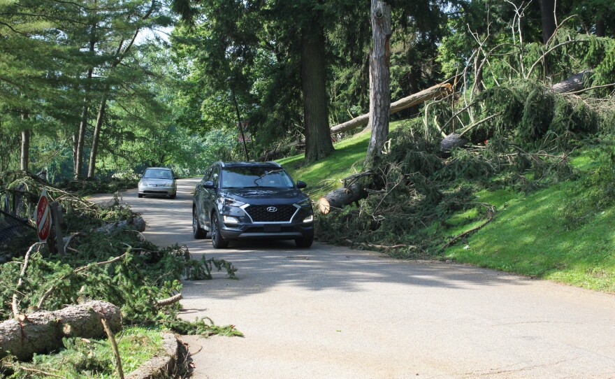
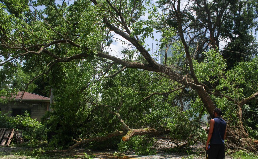
Residents of Wheeling were cleaning up Wednesday after a strong storm Tuesday morning.
Residents of Wheeling were cleaning up Wednesday after a strong storm Tuesday morning. The damage is significant, but isolated.
Generators, chainsaws, and woodchippers provided a soundtrack Wednesday as the Wheeling community recovered from the Tuesday morning storm that knocked out power to most of downtown, Wheeling Hospital, and several communities to the east.
The damage was severe enough that Gov. Jim Justice declared a state of emergency for Ohio County Wednesday afternoon that will remain in effect for 30 days.
At its height, the storm passed through the area with sustained winds of 60-70 miles per hour, and gusts of up to 80 miles per hour.
Lou Vargo, the Director of the Wheeling–Ohio County Homeland Security and Emergency Management Agency, says the trail of damage indicates a unique weather event.
“It’s a straight line event,” Vargo said. He is asking the National Weather Service to investigate.
“And they said, ‘So are you thinking a tornado?’ We’re not seeing the twisting of the trees coming out. It’s just literally uprooted these trees, 100 year old trees, three or four foot diameter trunks of trees that were just lifted right out of the ground,” he said. “You can almost look on a map and just draw a straight line, put an arrow and say ‘This is how it came through.’”
Some of the promised 100 work crews have already arrived to help restore power as quickly as possible. As of Wednesday evening, 7,000 residents remained without power, but an American Electric Power (AEP) representative said restoration would continue late into the evening.
The number of residents without power had improved to 5,000 by Thursday morning.
“This is an all hands on deck situation,” said Joelle Moray, External Affairs Manager with AEP.
Justice also announced members of the National Guard will be on the ground Thursday to help with cleanup.
No fatalities or injuries directly related to the storm have been reported. Vargo hopes it stays that way, and urges any residents using power tools or moving large downed trees and limbs to use caution.
Sections of trees downed by Tuesday’s storm had to be cleared to make roads in Wheeling Park passable. The park bore the brunt of the damage from the storm, and park officials estimate more than 100 trees were damaged.Workers in Wheeling Park feed debris into a wood chipper as part of cleanup efforts Wednesday. A strong storm on he morning of June 14 caused significant damage to the park’s trees.
To the east of downtown, Wheeling Park seemed to bear the brunt of the storm’s force. Park manager Nat Goudy said more than 100 trees were damaged, many of them large and decades old.
“Some massive, massive trees that were 50, 60 feet high, just drop, snap like a twig,” Goudy said.
So many trees were down Tuesday morning, Goudy said he couldn’t even drive into the park and had to come in on foot. The park’s roads had been cleared Wednesday, but the park was still without power. Goudy hopes it will be restored soon so the park can return to being a center of the community even as cleanup efforts continue.
“We’re the city park,” he said. “It was amazing seeing the support of the people coming in yesterday. ‘What can we do? Can we bring some rakes over? We’re here to help you.’ You know, just people who love the parks, want to make sure it stays open.”
Vicky Yost echoed that sentiment of camaraderie.
“In the middle of a catastrophe, in the middle of what could have been a tragedy, I looked up my lane and I saw eight of my neighbors coming down,” she said.
Yost lives across National Road from Wheeling Park in the Stamm Lane area, which was directly in the path of the storm.
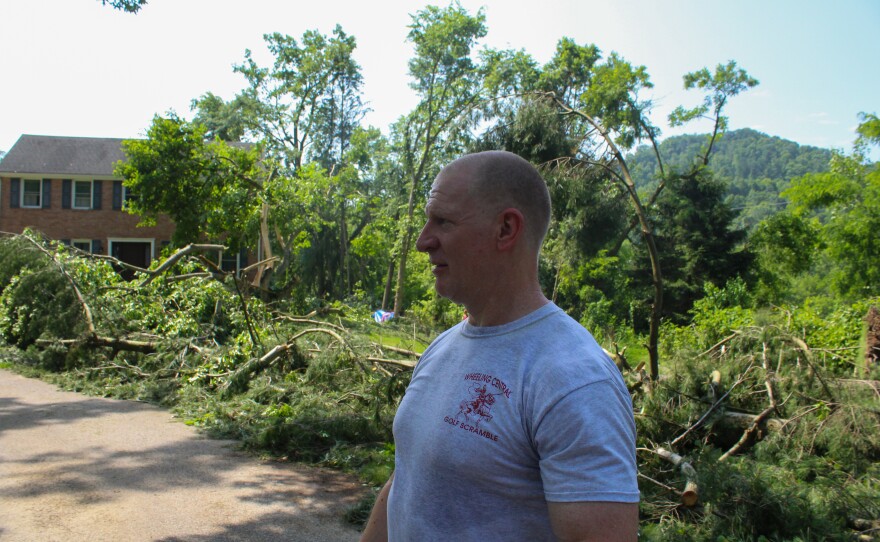
One of those helpful neighbors was Terry Huffman, who described being woken up by the storm.
“It was the wee hours of the morning. I’m not sure exactly what time but it hit hard and fast, five minutes, maybe,” Huffman said. “Literally the whole house shook and was as loud as a train going through your house.”
Huffman was helping the Yosts get a generator installed to make sure they had a way to cool themselves down.
“The biggest thing now is we have people without air conditioning, and it’s going to be really super hot today,” he said.
Terry Huffman assessed storm damage in front of his house in the Stamm Lane area of Wheeling. Huffman considered himself lucky, as falling trees just missed hitting his home during the June 14 storm.A black walnut tree blown over by the June 14 storm lies precariously over a street in the Stamm Lane area of Wheeling.
According to data from the National Weather Service in Pittsburgh, Wednesday’s high in Wheeling was 92. But with high humidity, the heat index –- or what the temperature feels like –- was closer to 100.
Tim Ritchie walked across the bridge from his home on Wheeling Island to access a cooling shelter in the WesBanco Arena. He said the walk, which normally takes him 15 minutes, took him an hour in the heat. If power outages persist along with high temperatures, his biggest concern is his elderly neighbors.
“Half the island’s pretty much no electric and there’s a lot of people that don’t drive,” Ritchie said. “I mean they offer bus service, but the elderly is not going to hop on the bus and come down here.”
Officials hope additional work crews will help get more people back on the grid quickly, but efforts may be stymied Thursday by even higher temperatures, and the threat of more storms through the afternoon and into the evening.
“We can restore power during a rain event,” Moray said. “The wind is the factor.”
AEP is monitoring the weather, but the company’s meteorologists believe any storms Thursday will not rise to the level of Tuesday’s event.
A man walks across 16th Street under a traffic light with no power in downtown Wheeling. In the background, just one block away, other traffic lights are functional. The June 14 storm left a focused line of destruction across the Wheeling area.A man looks at a tree completely blocking Grandview Street in the Vineyard Hills area of Wheeling. Work began on removing the tree, but was stopped due to the tree lying on a power line.Tuesday’s storm significantly damaged the roof of the West Virginia Department of Health and Human Services Mary Margaret Laipple Professional Building in downtown Wheeling.