


Your browser doesn't support audio playback.
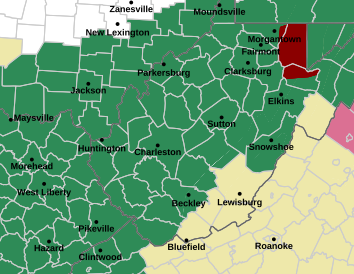
The National Weather Service (NWS) in Charleston has issued a flood watch through 8 a.m. Sunday for portions of northeast Kentucky, southeast Ohio, southwest Virginia and most of West Virginia.
In West Virginia, the watch extends to Barbour, Boone, Braxton, Cabell, Calhoun, Clay, Doddridge, Gilmer, Harrison, Jackson WV, Kanawha, Lewis, Lincoln, Logan, Mason, McDowell, Mingo, Northwest Fayette, Northwest Nicholas, Northwest Pocahontas, Northwest Raleigh, Northwest Randolph, Northwest Webster, Pleasants, Putnam, Ritchie, Roane, Southeast Fayette, Southeast Nicholas, Southeast Pocahontas, Southeast Raleigh, Southeast Randolph, Southeast Webster, Taylor, Tyler, Upshur, Wayne, Wirt, Wood and Wyoming.
The NWS says multiple rounds of showers and thunderstorms are expected through Saturday night.
Locally heavy rainfall is likely to raise the risk of flash flooding – especially for residents in areas already saturated with water, like parts of southern and central West Virginia up through Clarksburg.
“They could definitely have some heavy downpours, damaging winds possible, mostly across the Clarksburg, Elkins areas, up in that area of the state today,” Meteorologist Levi Cornett said. “Really, the heaviest of the rain, though, is going to be Friday and Saturday. We’re going to see numerous to widespread showers and storms in the afternoons both those days.”
Cornett said training storms – a series of storms that repeatedly follow the same path, hitting the same areas – are projected to hit Mingo and McDowell counties and parts of Kanawha County over the weekend.
“If you get certainly over an inch of rain, you could see ponding on roadways. If you get enough of it, you can see vehicles wash away with that, rivers can rise pretty swiftly, especially across our southern coal fields,” he said.
The NWS advises the public to monitor forecasts and be prepared to avoid roads and low-lying areas prone to flood.